


GPS Photo: With Location & Map
4.2120.00 Reviews
App Specs
- Version
- 4.2.0
- Updated On
- License
- Free
- Downloads
- 10,000,000+
- Developer
- Galaxy studio apps
- Categories
- Travel & Local
- Platform
- Android
Screenshots
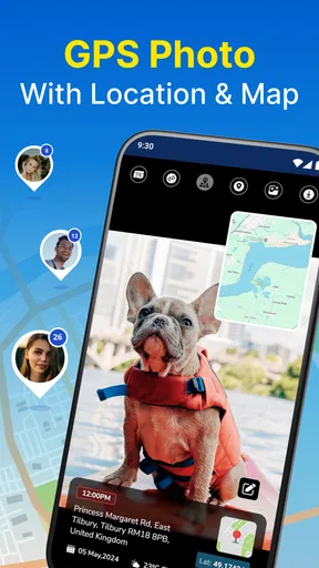
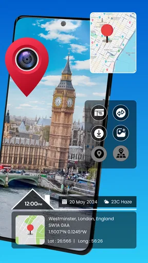
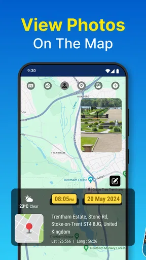

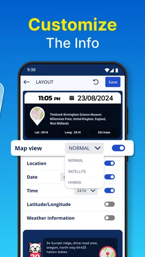

 Analysis by AppCompare
I like the idea behind GPS Photo: With Location & Map: a photo can be a memory and a record of where that memory happened. For a trip, a walk through an unfamiliar neighborhood, or a collection of property photos, seeing images connected to places can make them easier to revisit later. This is a travel and local app from Galaxy studio apps, and its appeal is quite specific: it adds a location-focused layer to taking and organizing pictures rather than trying to replace every camera or gallery feature on a phone.
What to expect when you open it
The app’s basic promise is easy to understand, which matters when you want to take a picture and move on rather than spend time setting up a complicated workflow. Its current version is 4.2.0, and the app is free to install, with optional in-app purchases ranging from $0.99 to $99.99 per item. That range is broad, so I’d check what an optional purchase actually covers before paying; the core idea is useful even if you are only testing whether location-marked photos fit your routine.
I would think of GPS Photo as a companion for particular outings, not necessarily as the camera I’d use for every situation. A quick snapshot in familiar surroundings may not need a map or an added label. But when the place is part of the photo’s value, having location information close to the image can save the effort of trying to identify a turnoff, viewpoint, or café weeks later. The distinction is practical: this tool is most compelling when you expect to ask yourself, “Where exactly was that?”
How its pace fits a day out
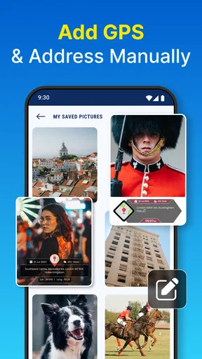
For ordinary use, the workflow described by the app is direct: take a picture with its in-app camera, or bring in an existing image and add location information. That gives it two useful entry points. I can use it at the moment I take a photo, or make a later pass through pictures from a trip. The second option is especially handy when I have a few memorable images that deserve context but did not get organized while I was traveling.
In practice, I’d keep the job small and deliberate. After a walk or a day of sightseeing, I might pick a handful of photos whose locations matter, rather than turning every image in my camera roll into a mapping project. That keeps the map meaningful and makes it easier to find the images I actually want to revisit. If a photo’s location is uncertain, I would check it before adding or relying on the tag; retroactive organization is useful, but it still depends on having a good reason to associate that picture with a place.
Busy outings and the trade-offs
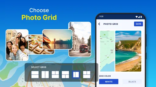
The app makes most sense when location is part of the record: documenting a sequence of stops, keeping track of scenic viewpoints, or saving images that will later help you retrace a route. A map can reveal that several apparently unrelated pictures belong to one area, while a watermark can make a single image easier to understand when it is shared outside the gallery. Those are different jobs, so I’d choose the map for browsing a collection and a watermark when the location needs to be visible on the image itself.
There is a trade-off to that extra context. Labels can make a photo more useful as a record, but they can also distract from the image or expose more location detail than you want to share. I’d be selective with watermarks, especially for pictures taken near home or anywhere I would not want to identify publicly. For a personal travel album, the map may be enough; for a work record, a visible label might be worth the added visual clutter.
Worth Reading Before You Choose

Flipboard Shows What News Apps Must Do Beyond the Feed

Switching to Android Auto Means Rethinking Your Driving Routine

Google Calendar Makes a Crowded Week Easier to Manage

Ludo King Makes the Most of the Minutes Between Plans

Baby Panda World Brings Quick Play to Modern Phones, but Its Game Library Feels Busy

ESPN’s Live Game View Makes Following Close Games Easier
Reliability, offline use, and practical limits
One appealing detail is the stated offline behavior: the app can keep tagging photos without a signal and update information when connectivity returns. That can suit a rural drive, a trail, or a trip where mobile service comes and goes. I would still treat location capture and online map viewing as separate needs. Saving a location while offline does not make a live map available in a dead zone, so I would not rely on the map as my only navigation tool.
For consistency, it helps to pause briefly before taking a location-sensitive picture, especially after moving between places. That gives the phone a better chance to establish where you are before the image becomes part of your record. If a result looks misplaced, I would review it rather than assume that every tag is exact. GPS-based tools are only as useful as the location they receive, and a dense city street or a quick stop can make precision more important than speed.
Why Choose GPS Photo?
Imagine this: you’re on a road trip, capturing stunning landscapes and quirky roadside attractions. A few weeks later, you’re scrolling through your photo gallery, and you can’t remember exactly where you took that amazing sunset pic. Enter GPS Photo: With Location & Map. It automatically tags your photos with GPS coordinates, so you’ll always know precisely where each photo was taken.
Features That Stand Out
Now, I know what you’re thinking—there are tons of apps out there that add location data to photos. But here’s where this app shines:
- Easy-to-use Interface: The app is designed with simplicity in mind. You don’t need to be a tech whiz to navigate through its features.
- Map Integration: View your photos on a map, and relive your journeys by seeing exactly where each snapshot was taken.
- Customizable Watermarks: Add your own personalized touch with watermarks that include location, date, and more.
- Offline Mode: No signal? No problem. The app can still tag your photos, saving the data to update once you’re back online.
Using the App
Getting started with GPS Photo is a breeze. Once you’ve downloaded and opened the app, you’ll find a straightforward layout. Simply snap a photo using the in-app camera, and voilà! Your photo is instantly tagged with all the location data you need.
If you’re like me and have a bunch of photos already saved on your device, don’t worry. The app allows you to import existing photos and add location data retroactively. It’s a lifesaver for those forgotten trip pics.
Who Will Love This App?
This app is perfect for travelers, bloggers, and even real estate agents who need to document locations with their images. It’s also great for anyone who loves keeping their photo collection organized.
Personally, as someone who often revisits places, having a visual map of my photo journey is invaluable. It’s not just about the photos; it’s about capturing the full experience, and this app does it beautifully.
Final Thoughts
At the end of the day, GPS Photo: With Location & Map is more than just a utility app. It’s a storytelling tool that enhances the way we capture and remember our adventures. Whether you’re a globetrotter or just love snapping pics around town, this app is worth a spot on your home screen.
So, go ahead and give it a try. You might just find that it becomes an indispensable part of your photo-taking routine. And who knows? Maybe next time you’re looking at that picture-perfect sunset, you’ll remember exactly where you were, thanks to a little help from GPS Photo.
When another camera or map is the better fit
I would not replace a phone’s usual camera with this for every shot. If I care most about familiar camera controls or want to keep a fast, uninterrupted shooting rhythm, the standard camera is the simpler choice. GPS Photo earns its place when location is the point of the record, not merely an extra detail. A separate map app is also better when I need directions or route planning; a photo map helps me look back at where images belong, but it should not be mistaken for a navigation tool.
A useful routine is to leave everyday snapshots alone and use this app for deliberate records: a notable stop on a long drive, a house viewed for work, or a landmark whose name I may forget. When I import pictures later, I would sort by outing first and add context only to images I can confidently place. That prevents a tidy-looking map from giving false certainty about a photo’s location.
Who should try it—and who can skip it
It is a natural fit for travelers who revisit old pictures, bloggers who want place context attached to visual notes, and people who document locations for practical reasons. It can also help anyone who prefers remembering a route through images rather than maintaining a separate written list. The app has an Everyone content rating, and its audience is broad, but its value still depends on whether location adds something to your own photo habits.
If you rarely search photos by place, already have a location workflow you trust, or mainly want a camera with extensive creative controls, I would skip it or try it only for one outing. The same goes for anyone who dislikes visible text across images: watermarks can be useful evidence, but they change the look of a photograph. A clean original remains preferable when the image itself matters more than its documentation.
Support, ratings, and the device decision
GPS Photo has a 4.1 average from around 86 thousand ratings and more than 10 million installs, so it is an established option rather than an obscure experiment. Those figures suggest plenty of people have tried it, but they do not tell me whether its workflow will suit a particular phone or personal preference. Galaxy studio apps is the developer, and the app is available for devices running Android 8.0 or later.
Because it works with photos and location, I would expect the experience to depend partly on the phone’s ability to provide a usable location and on how many images I choose to handle. I would avoid processing a large backlog in one sitting if I did not need to; working in smaller groups makes it easier to spot a misplaced result and keeps the task manageable. I also would not assume that adding map context is cost-free in every sense: beyond any optional purchase, it asks for attention, storage space for the pictures already on the device, and care when sharing location-revealing images.
My performance verdict
My expectation is a focused utility rather than a demanding all-purpose photo editor. The simple capture-and-tag concept should suit quick documentation, while importing and organizing a large collection is naturally a slower, more hands-on task. I would judge its speed by whether it lets me record a useful location without interrupting an outing, not by how many editing tools it offers. For a single photo, the value is convenience; for a whole archive, patience and selective organization matter more.
The offline option gives the app a practical role beyond city sightseeing, but I would still verify important locations and keep another source of directions for unfamiliar terrain. If the app behaves unexpectedly, I would first check whether the phone has a location fix and whether the image itself is one I can place accurately, rather than treating a map marker as unquestionable proof. That is a sensible habit with any GPS photo workflow.
A grounded recommendation
GPS Photo is worth trying if you often return to pictures wanting to know where they were taken, or if you need images to serve as location notes as well as memories. Its most useful quality is the bridge between a photo collection and a map, with the option to make context visible through a watermark. The best results come from using those tools intentionally: choose the images that benefit, review uncertain places, and think before sharing precise location details.
For me, that makes it a useful companion rather than an essential camera replacement. Its 4.2.0 release is free to start with, while optional purchases are available, so I would explore the basic workflow before deciding whether anything paid is worthwhile. If your photos are mostly visual keepsakes, your regular gallery may be enough. If place is part of the story, this app gives you a straightforward way to keep that context close.
Pros
- Easily tags photos with precise GPS data.
- Intuitive interface for all user levels.
- Offline map support for remote areas.
- Seamless integration with social media.
- Customizable settings for photo details.
Cons
- Consistent GPS usage drains battery quickly.
- Limited editing features for photos.
- Occasional app crashes on older devices.
- Requires internet for map updates.
- Some features locked behind paywall.
FAQs for GPS Photo: With Location & Map
What is GPS Photo: With Location & Map?
GPS Photo: With Location & Map is an app that allows users to capture photos with geotags and view them on a map. It integrates GPS data to provide detailed information about the location where each photo was taken, making it easy to organize and share your photographic journeys.
How does GPS tagging work in this app?
The app uses your device's built-in GPS to automatically add location data to each photo you take. This geotagging feature records the exact coordinates and displays them on a map, allowing for easy navigation and organization of your photos based on where they were taken.
Is an internet connection required for using GPS Photo: With Location & Map?
An active internet connection is not required for basic functionality, such as taking photos and geotagging them. However, for features like map integration and sharing your photos with location data, an internet connection will enhance the user experience, ensuring maps are up-to-date and sharing is seamless.
What are the privacy considerations when using this app?
Privacy is an important aspect to consider when using GPS Photo: With Location & Map. The app collects location data to provide its core functionality, but users should be mindful of sharing geotagged photos publicly, as this could reveal sensitive location information. It’s advisable to adjust privacy settings according to personal preferences.
Can I edit the location data on my photos?
Yes, GPS Photo: With Location & Map allows users to edit the geotagging data associated with their photos. This feature is particularly useful if you want to correct inaccuracies or customize the location information before sharing the images. The app provides an intuitive interface for making these adjustments easily.


